8-09-04 Cougar, Washington to Bend, Oregon
I did not quite know where I was. Cougar wasn't on my map. I backtracked east to the Gifford Pinchot National Forest station.
Both of the park employees at the station were from San Diego. Both loved their new home. Al used to ride scooters for the mpg. He moved up to a 90cc 2 stroke when he moved to the mountains, since the scooters had a tendency to poop out on the climbs.
They directed me to the 30 south to Carson… a five mile downgrade with no straight stretches for those who love curves.
The weather was just great, the air changing from warm to hot and back to warm. As I traveled through the mountains, the temperature constantly changed. I would ascend a hill into a strata of warm air and then descend into pools of cool air. I could feel the passage of colder air moving through the ravines. The road took me into Carson, Washington for lunch. I could ride for a long time in those conditions.
I stopped at an overview to take pictures of Mt. St Helens. A different side? The mountain had a different profile.
The 14 swung east, alongside the Columbia River on the Washington side. The road passed through several short tunnels.
The temperature finally heated up enough for me to stop at a riverside park, remove my jacket's inner lining, and to open the jacket's vents.
14 crossed over the Columbia River at the its junction with 97. There was a long climb out of the river valley to a 2500' pass. The air seemed to cool slightly.
As always, there were the Cascade volcanoes in the distance. The Cascades rise in isolation, unlike the continuous range of the Sierras. As one disappeared behind me, there would be one to the right pacing me and another looming ahead. I stopped at a marker with pointers to the various peaks, but someone had stolen all of the labels. 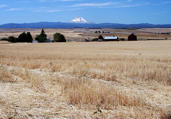 This area of the 97 was fairly
unpopulated. There were huge fields of what, wheat, hay,
hops? Interesting patterns left by
agriculture swirled the hillsides. |
The 97 ran fairly straight with passing lanes to get by the occasional slow traffic. I held the bike at a constant 65 – 70 mph indicated in a 60 mph zone. At Maupin, I stopped for a soda. The Deschutes River ran through town, alongside a large landing. Maupin was a big put-in spot for river rafters. There was a constant stream of SUVs with rafts on roofs, and trucks hauling trailers loaded with canoes driving by. From Maupin, the 97 linked to Madras. After Madras, the character of the road changed. The approach to Redmond passed through the heart of town with 4 lanes of traffic. Past Redmond, the 97 became a quasi- freeway heading to Bend, Oregon In Bend, located close to the center of the State of Oregon, I exited on the first road with signs indicating hotels and gas. I needed both, along with a decision to stop early to get decent maps from a visitor information center. I picked out two maps highlighting scenic roads to the Cascade volcanoes. What was left was to figure out where I was in Bend. Klamath Falls was a straight shot of about 2.5 hours away, but I would look for a long, indirect route in the morning. I called my parents. My dad asked me to find and check out an aircraft builder of RV airplane kits at the Bend Airport. His name is Dutch, and he sells a lot of planes to the population of Ottawa Executive Airport, where my father's airplane is based.
|


