|
7-31-04 Dawson, Yukon to Chicken, Alaska to Tok, Alaska. There was a yellow F650 BMW parked next to KLR in the morning. Mick from Pittsburgh, PA ran the Dempster without gear. He had kept a detailed account of road conditions and confirmed Fort McPherson as a tough spot. I asked him if he intended to publish his information. He did not. He had another story of a large BMW giving its driver a header. More than ever, I think the right bike, particularly on the Dempster, is the KLR. I almost ate a ditch in spite of my opinion of the right bike. The morning was foggy, cool, and partly cloudy. I did not sleep well during the night. I woke up with no indication as to the time of day, but it was early. I reloaded the gear back onto the bike after coffee and oiling the chain. Back to Dawson, and through the construction zone just outside of the city limits. It was wet, tracked, and slippery. I tried to find some rain boots but had no luck. Looks like I'm back to using garbage bags on my feet and looking stupid. I crossed the Yukon River by ferry and disembarked onto the Top of the World Highway, which lived up to its name. |
I was above the fog, riding the top of a ridge with views to both sides. 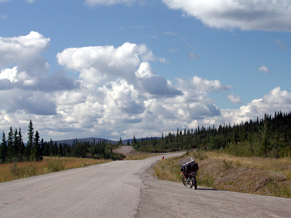 |
The road started out paved and turned into gravel. I checked in at the U.S. border without incident – my wallet close at hand in my jacket pocket. A few questions and I was on my way. The gravel road to Chicken was in good shape, but I had to watch my approach speed into curves. Also, there was a 39 member caravan of RVs I think I had met earlier on a different road. I kept passing them one by one. I was making steady time in dry weather to Chicken. A deserted cabin stopped me for a few minutes of exploration. 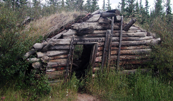 |
| I arrived in Chicken, a town named by its citizens who couldn't spell "ptarmigan". So they called it Chicken instead. The famous Chicken denizen and restaurant/bar owner, Chicken Sue Lady, was in Anchorage to be with her son, who had injured himself in a paint thinner explosion. I bought a couple of souvenirs at a nearby shop. I lamented on my lack of a pan and the store owner offered me free panning in the spoils pile near the store. I deferred, with thanks, to reaching the town of Tok. I had an All-American hotdog and potato salad at the café next door, and got back on the road. |
About 2 miles out of Chicken, the road became paved. I ran my speed up to an average of 65 – 70 mph, slowing for the occasional patches of gravel. Most of the area had burned. I had passed a slow-moving car earlier, and as I went by, I was startled to see that the driver was reading the Bible as he drove. He had the Bible laid open by his side, and was constantly scanning between the windshield and the Bible. No wonder he was driving so slow... 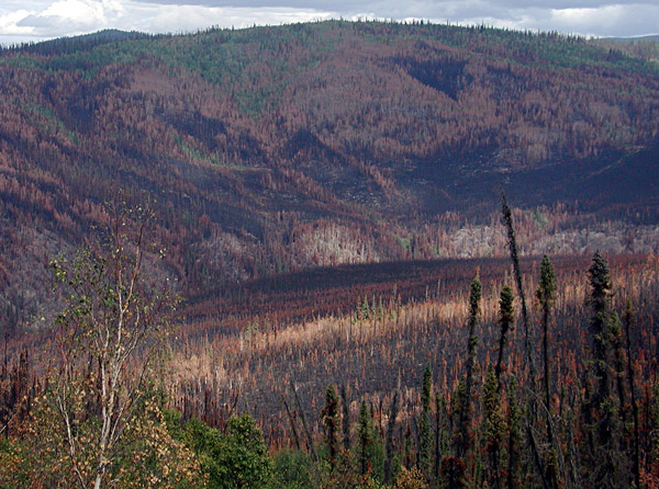 When
I stopped to take this picture, the car with the Bible-reading
driver caught up to me. He rolled down his window and asked if I
was alright. I told him I was just admiring the view and thanked
him for his concern. |
Fires were still burning in the distance. 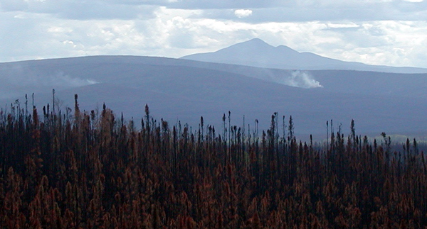 I came to a T intersection and turned north to
Tok. I booked a hotel at 3:30 PM, an early
day. Tomorrow, Anchorage or south, depending on if the volcano was getting ready to blow. |
| At Tok, I had a chance to get internet access at the hotel, so I checked my mail and sent emails to friends. I also picked up a newspaper and got a decent snapshot of the weather for the first time in days. The afternoon was warm and sunny: I ate dinner on the sunny outside patio of a restaurant. But the weather map showed the Arctic Low to the northwest, chasing after me. The newspaper also carried an update of the activity at Mount Spur. The mountain's state was steady: an eruption was not anticipated at any time in the near future. So, south would be my direction, away from Alaska and towards home. I was able to connect by telephone to my friends John and son Steven, Brian and son Ryan, and to my daughter Allison, who were on the flanks of White Mountain attempting to reach the peak. As a group, we try to set one significant peak per year as a hiking goal. White Mountain is a 14,282 ft. mountain located across the Owens Valley from Mount Whitney. We had climbed Whitney. Two of us had climbed White on a later trip, but a lack of time had closed out John and Brian. Another attempt to get everyone to the top of White had been planned for the summer without me, since I had my arctic plans. The hike results: Brian and Ryan made it. The others did not. Allison and Steven had altitude sickness and Allison blew her dinner. John took them down to a lower altitude while Brian and Ryan hiked the peak. Brian discovered his old abandoned t-shirt on the trail. The last hike on White had left Brian with a trailside emergency and nothing at hand... he had to improvise. This time, he had another trailside emergency, but had brought paper. The toilet paper came with its own problems: the winds blew the paper back into his face. I don’t know if last year's t-shirt came back with him or if it is still blowing in the winds of White. |
   |
 |